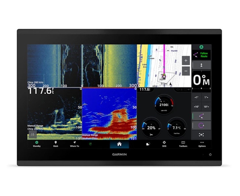
Garmin GPSMAP 9217XSV — Ultimate Command with Sonar and Clarity.
For captains and serious anglers, visibility and precision aren’t optional — they’re mission-critical. The Garmin GPSMAP 9217XSV combines a massive 17-inch WUXGA touchscreen with pro-grade chartplotting and sonar technology, giving you full command over your boat and the waters beneath it. Whether you’re scouting offshore wrecks, marking reefs inshore, or navigating complex channels, this display keeps your data sharp, your course locked, and your fishing strategy on point. Garmin GPSMAP 9217 Navionics Vision+ Chart Bundle
Rugged and ready for the elements, the 9217XSV is built for the long haul. Its sunlight-readable, edge-to-edge display cuts through glare for clear charts even under the brightest midday sun, while the IPX7-rated housing handles spray, rain, and rough seas without missing a beat. Intuitive touchscreen controls make navigation simple and seamless, so you can focus on the bite or the run ahead instead of fumbling through menus. From sportfisher to yacht bridge, this unit commands the helm with clarity and confidence. Garmin GPSMAP 9217 Multifunction Display
Under the hood, multi-constellation GNSS (GPS, GLONASS, Galileo, BeiDou) ensures rock-solid positioning even in tight channels or offshore, where accuracy matters most. With the ability to store thousands of waypoints, tracks, and routes, you can return to your favorite fishing spots or hidden anchorages with pinpoint accuracy. Preloaded Garmin Navionics+™ mapping for coastal and inland waters, along with QuickDraw Contours, ensures you have the most detailed navigation and bottom contours at your fingertips. Garmin ECHOMAP Ultra 2 166sv Ice House System
Included in this bundle is a Garmin Navionics Vision+ chart card. Garmin Navionics Vision+ charts include both coastal and inland coverage within the region of your choice. Data is sourced from Garmin and Navionics to provide you with exceptional detail. These charts include 1-year of daily updates, ensuring your chart data is always current! Premium features include High Resolution Relief Shading, High Resolution Satellite Imagery, Sonar Imagery, Aerial Photography, SideScan Images, and More! Garmin Navionics Vision+ charts require premium content to be downloaded post-purchase. Garmin GPSMAP 1643xsv GN+ Navionics Vision+ Bundle

The “XSV” distinction makes this more than just a chartplotter — it’s a complete sonar command center. Supporting high-definition CHIRP, ClearVü, and SideVü scanning, the 9217XSV lets you see structure, bait schools, and predators in unprecedented detail. You can track bottom composition and underwater features with precision, helping you find the strike zone and outsmart the fish every time. Combined with your preferred transducer, this unit becomes a full-blown fishing and navigation hub. Garmin GPSMAP 9219 GN+ Navionics Vision+ Bundle
Installation and integration are effortless. The 9217XSV can be flush, flat, or bail-mounted and integrates seamlessly with the Garmin Marine Network, NMEA 2000, and wireless systems. Connect radar, autopilot, cameras, and engine data for a complete bridge setup, and use the ActiveCaptain® app to plan trips, update charts, and share waypoints directly from your mobile device. The Garmin GPSMAP 9217XSV is the ultimate tool for mariners who demand precision, durability, and total control on every voyage. Big screen. Big sonar. Total command
Each Garmin GPSMAP 9217XSV Navionics Vision+ Chart Bundle Comes with:




Reviews
There are no reviews yet.